- AppSheet
- AppSheet Forum
- AppSheet Q&A
- Working off-line
- Subscribe to RSS Feed
- Mark Topic as New
- Mark Topic as Read
- Float this Topic for Current User
- Bookmark
- Subscribe
- Mute
- Printer Friendly Page
- Mark as New
- Bookmark
- Subscribe
- Mute
- Subscribe to RSS Feed
- Permalink
- Report Inappropriate Content
- Mark as New
- Bookmark
- Subscribe
- Mute
- Subscribe to RSS Feed
- Permalink
- Report Inappropriate Content
I am currently having an app tested for working off-line collecting road data in Bourke, NSW. It's probably as remote as you can go. The council has internet access but for only approx. 25% of the surrounding area. The app is currently on an iphone 12. The person involved has been having problems with the app when off-line. He is using google maps on the app and when offline the map disappears so he cannot easily find the asset to amend. He is collecting photos as well.
We have had a range of problems when setting different switches. the current switches that are on are
- Delayed sync for manual syncing
- The app can start when offline
- Store content for offline use
One case as follows "
Solved! Go to Solution.
- Mark as New
- Bookmark
- Subscribe
- Mute
- Subscribe to RSS Feed
- Permalink
- Report Inappropriate Content
- Mark as New
- Bookmark
- Subscribe
- Mute
- Subscribe to RSS Feed
- Permalink
- Report Inappropriate Content
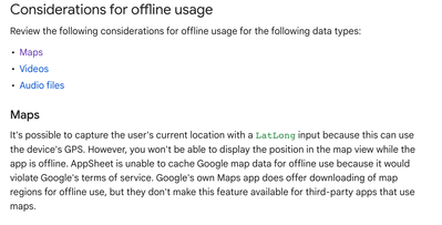
Certain capabilities are not available when users are offline because they require connections to external services. You can get most of the details in this article:
Offline and Sync: The Essentials
For example, the article covers this (note the comment about caching map data):
- Mark as New
- Bookmark
- Subscribe
- Mute
- Subscribe to RSS Feed
- Permalink
- Report Inappropriate Content
- Mark as New
- Bookmark
- Subscribe
- Mute
- Subscribe to RSS Feed
- Permalink
- Report Inappropriate Content
I appreciate your response. If I have a client wanting to use the feature what can be done?
- Mark as New
- Bookmark
- Subscribe
- Mute
- Subscribe to RSS Feed
- Permalink
- Report Inappropriate Content
- Mark as New
- Bookmark
- Subscribe
- Mute
- Subscribe to RSS Feed
- Permalink
- Report Inappropriate Content
@Alexander_Muir wrote:
If I have a client wanting to use the feature what can be do
Do you mean using mapping capabilities while offline? In general you can't.
Apps don't permanently store map images. However, if they have accessed the location before going offline, they will have a map image to view while offline. I don't know how long it is persisted though.
If the client truly needs full mapping access to work in remote areas, there are connection services that provide special hardware that can allow internet in these areas. They are mobile and the phone would simply connect to that network to have the online access it needs. I have checked into some of these internet services and they are not overly expensive and would likely work well for a business.
- Mark as New
- Bookmark
- Subscribe
- Mute
- Subscribe to RSS Feed
- Permalink
- Report Inappropriate Content
- Mark as New
- Bookmark
- Subscribe
- Mute
- Subscribe to RSS Feed
- Permalink
- Report Inappropriate Content
One other idea came to mind while I was reading another post.
You can create KML map layers. These typically use a static image as a background - a map, blueprint, diagram, etc. Then you can overlay items onto that background image.
For more details, and examples of how KML Layers can work, visit this article and scroll to the KML Map Layers section:
There is a LOT you can do with KML Layers - which translates to a large learning curve!
-
Account
1,864 -
App Management
4,148 -
Automation
11,565 -
Bug
1,583 -
Data
10,861 -
Errors
6,554 -
Expressions
13,079 -
Integrations
1,975 -
Intelligence
695 -
Introductions
118 -
Other
3,400 -
Resources
683 -
Security
935 -
Templates
1,542 -
Users
1,822 -
UX
9,824
- « Previous
- Next »
| User | Count |
|---|---|
| 16 | |
| 10 | |
| 8 | |
| 5 | |
| 5 |

 Twitter